Destination Detail Report
Rongai Route Expedition
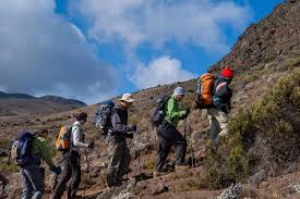
High-altitude summit journey with dramatic climate zones, demanding elevation gain, and strong safety-led expedition support. Rongai Route Expedition in Mount Kilimanjaro is ideal for travelers seeking clear structure and guided confidence.
Detailed Destination Table
| Category | Details |
|---|---|
| Climate | Variable alpine mountain climate. Warm lower slopes, cold summit zone, and possible night frost/wind above 4,000m. |
| Vegetation | Rainforest to moorland, alpine desert, then arctic summit terrain. |
| Location | Mount Kilimanjaro |
| Dangers | Altitude sickness risk, cold exposure, dehydration, and fatigue if pace is not controlled. |
| Altitude | Approx. 1,600m to 5,895m (Uhuru Peak) depending on route stage. |
| Safety | Daily health checks, acclimatization pacing, qualified mountain guides, and evacuation-ready protocols. |
| Program | 7 days · Mount Kilimanjaro |
Day-by-Day Route Table
| Day | Camp / Stage | Altitude | Vegetation Zone | Distance (km) | Daily Report |
|---|---|---|---|---|---|
| 1 | Simbu Camp | 2,650m | Montane forest | 8 km | Entry from the northern trailhead through forest and open ridgeline approaches. |
| 2 | Kikelewa Camp | 3,630m | Moorland | 11 km | Gradual ascent with sweeping views toward Kenyan plains and drier northern slopes. |
| 3 | Mawenzi Tarn Camp | 4,330m | Alpine heath | 6 km | Steeper altitude gain to high camp below Mawenzi with strong acclimatization benefit. |
| 4 | Mawenzi Tarn Acclimatization | 4,330m | Alpine heath | 5 km | Acclimatization walk and recovery to improve summit readiness. |
| 5 | Kibo Hut Camp | 4,700m | Alpine desert | 9 km | Traverse the saddle between Mawenzi and Kibo; early rest for summit push. |
| 6 | Horombo Hut | 3,720m | Heath and moorland | 21 km | Midnight ascent to Uhuru Peak then controlled descent to Horombo. |
| 7 | Marangu Gate Exit | 1,860m | Rainforest | 20 km | Final descent through rainforest and return transfer. |
